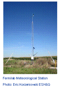
Welcome to Fermilab's weather data site (provided by the Environmental Protection Group of the ESH&Q Section). Fermilab’s meteorological (met) station became operational in 1992. Located in open field, the station is solar powered and consists of a 30-foot tower (as of September 2002) to which the following instruments are attached: temperature and relative humidity sensor, tipping-bucket rain gauge, combined wind speed and direction sensor, barometer, and pyranometer. The station’s geographical location is North 41º 51' 22.5", West 88º 14' 19.0" at an elevation of 740.7 feet above Mean Sea Level (MSL). See an aerial photo of its location (near New Muon Lab) on site.
 An electronic data
logger at the station is programmed to record measurements from each sensor
once a second and report current conditions with hourly and daily summaries
including selected maximums, minimums, and averages.. The
“Current Conditions” frame (left) displays these measurements updated every
minute. In addition, heat index and wind chill are calculated and displayed, as
applicable. The current hour precipitation is reset at the top of each hour.
Archived data is maintained by the ESH&Q Section.
An electronic data
logger at the station is programmed to record measurements from each sensor
once a second and report current conditions with hourly and daily summaries
including selected maximums, minimums, and averages.. The
“Current Conditions” frame (left) displays these measurements updated every
minute. In addition, heat index and wind chill are calculated and displayed, as
applicable. The current hour precipitation is reset at the top of each hour.
Archived data is maintained by the ESH&Q Section.
Precipitation data are collected by the tipping-bucket rain gauge. Previously a weighing-bucket rain gauge (installed May 1993) provided analog precipitation data for the snow-producing months. In January 2002, the tipping-bucket rain gauge was upgraded to include the capability of providing precipitation data during the snow-producing months. At that time the weighing-bucket rain gauge was taken out of service. Depending on the air temperature and the intensity of sunlight, some delay may exist between a snow event and the data recording.
The dew point temperature is calculated based on measurements of temperature and relative humidity. Relative humidity is the ratio of the amount of water vapor in the air to the maximum amount of water vapor the air can hold (for a given temperature), expressed as a percentage. Dew point temperature is the temperature at which the relative humidity equals 100% and moisture in the air can condense to create fog.
The pyranometer measures solar radiation (sunlight) for the hemisphere of sky above the sensor, and reports it as an average flux density in W/m².
See the relationship between solar radiation and air temperature throughout a year.
View data recorded during a solar eclipse.
The “Wind Gust” measurement is the maximum wind speed in the previous minute recorded.
The wind direction sensor measures the wind direction in degrees. If the measurement is 0º, the wind is from the north. If the measurement is 90º, the wind is out of the east. The met station is oriented where 0º is “true” north. True north is the Earth’s northern rotational axis, as opposed to magnetic north, which varies through time.
Questions, Questions, Questions
Q. Why does Fermilab have a meteorological station?
A. The primary purpose of the met station is to provide data for compliance with 40 CFR 61.93(a) Emission Monitoring and Test Procedures. Additionally, it provides precipitation information to construction managers for post-storm erosion control inspection requirements at on-site construction projects. Over the years people have found various other uses. Aside from regulatory purposes: it assists the physics mission of the Lab by providing data to Accelerator Division for correlation of expansion/contraction of accelerator components to environmental conditions. Providing wind conditions can aide Roads and Grounds in prairie burn safety with respect to smoke dissipation. Meteorological data also can support recreational activities by providing on-site conditions to model-aircraft enthusiasts (The Fermilab Barnstormers) at the Frelo Flying Field.
Q. Why isn’t the time adjusted for daylight saving?
A. Adjusting the time would create a one-hour data gap in spring while in autumn one hour would be repeated. This complicates the importation of data into software modeling programs and can create unexpected issues for assorted automated systems using the data. Additionally, by leaving the time as Central Standard Time (CST) an entire data set can easily be converted to Coordinated Universal Time (UTC) by adding six (6) hours to each time.
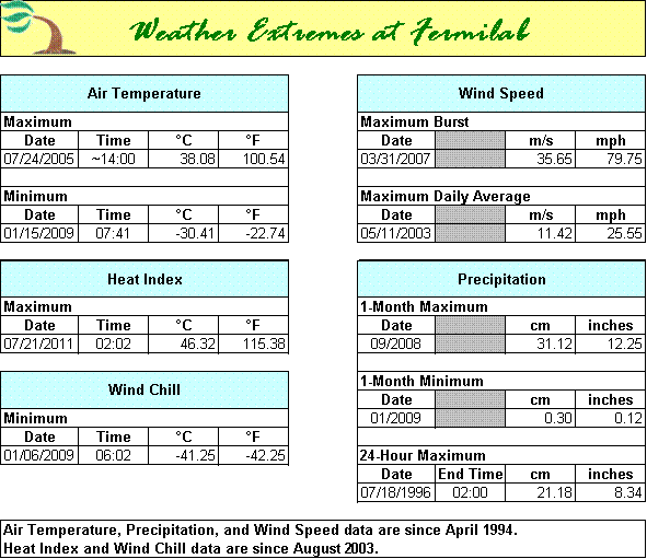
Q. What was the highest wind speed, coldest temperature, etc. recorded at Fermilab?
A.
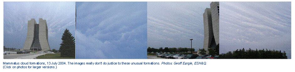
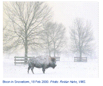
Weather Images
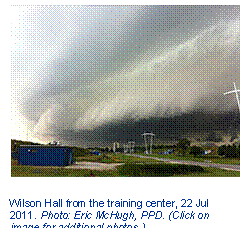
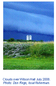
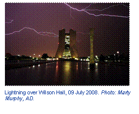
Above images previously published in Fermilab Today.
Weather-Related Links
 Current Conditions & Forecast at Batavia,
IL (weather.com)
Current Conditions & Forecast at Batavia,
IL (weather.com)
Current Weather Conditions at Aurora Municipal Airport (National Weather Service)
Historical data from Weather Underground (search Batavia)
Illinois State Climatologist’s Office – Illinois State Water Survey (ISWS)
National Oceanic and Atmospheric Administration (NOAA) Home Page
National Weather Service Enhanced Radar Image Loop for the Chicago, IL area
National Weather Service Forecast Office for Chicago, IL
NOAA Weather Radio for Northeastern Illinois live on the Web!
Severe Weather at Fermilab (.pdf file)
Subscribe to receive National Weather Service (NWS) alerts (for Northeastern Illinois) via email.
United States Geological Survey (USGS) National Water Information System
Wind Chill Chart or Heat Index Chart (.pdf files) (provided by NOAA)
Disclaimer: Data provided pertain exclusively to the Fermilab Meteorological Station and do not constitute “official” measurements. All data are provided “as is” for general informational purposes only. Any other use is at your own risk.
Please contact ESH&Q with any questions or comments.
Page last updated: September 24, 2013